:')
Saturday, 23 February 2008
Sunday, 12 August 2007
You can't please all the people...
cola9009 over on the on-one forum warns of the 'extreme nature' of the route.
I've been pleased by the number of folk who've been chatting to me about the route this weekend at SITS. All with the experience necessary for success.
Friday, 3 August 2007
Rules - There need to be some.
I'm not one for rules really, but I thought the following made sense.
This is a ride not a race.
No entry fee.
No prizes.
Bring a bike, whatever you like a crosser, mountain bike, bmx you be the judge.
Ride from start to finish under your own power, buy chips, gravy, bike bits, ciggies etc in towns, even stay in a B+B. Do not pre stash stuff en route, or have someone meeting you with provisions, no dossing at mates houses.
There is no support, no broom wagon.
You are on your own.
I can provide the route in a format suitable for following on your gps in advance.
No paper map is issued.
There is no cut off time, but you should be reckoning on getting round in under 48 hours.
Common sense says copy the route on to a paper map and carry a compass.
If you don't know the lake district, go and have a look see, route finding can be difficult.
Thursday, 2 August 2007
The Route

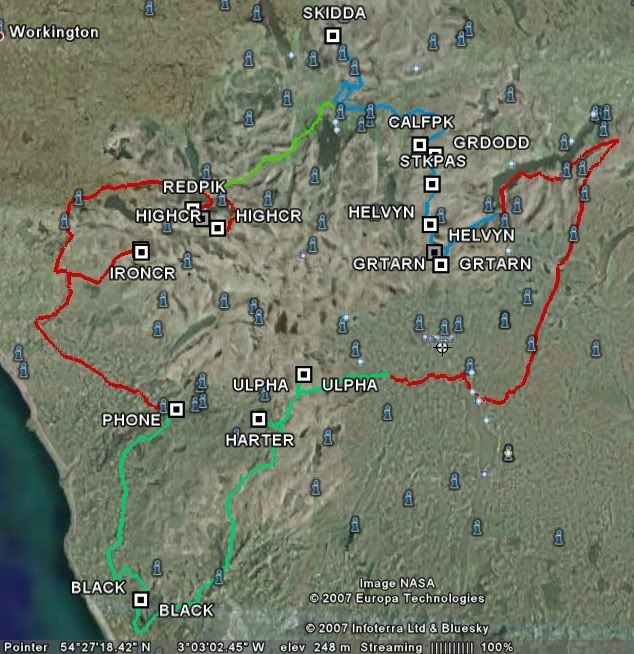
The route goes in a clockwise directiom from Eskdale, and visits the following hills.
Iron Crag, Red Pike, High Stile, High Crag, Skiddaw, Calfhow pike, Raise, White Side, Brown Crag, Hevellyn, Nethermost Pike, Dollywagon Pike,Loadpot Hill, Wether Hill, High Raise, Rampsgill Head, High Street,Ulpha Fell (Cockley beck), Harter Fell, Black Combe.
Mapped in google earth.
The riding varies from road to very technical, and of course the inevitable hike a bike.
I have .gpx files hosted over at http://www.bikely.com you'll most likely need to be registered, once you are search for "lugger" and the five files should show.
If you have tracklogs, then .trl files are hosted at http://www.bogtrotters.org/downloads/LakesLug
Of course you can always ask me and I'll email the files over.


